Geographic Information Systems
A good mapping system is the foundation for the Assessor's property location, inventory, and identification functions. Assessment maps (also called cadastral maps) show the boundaries of land parcels and display the size and location of each parcel relative to adjacent properties, roads, bodies of water, and other major physical or cultural features. Along with the boundaries for each property, the maps display the dimensions or areas of each parcel, street and road right-of-ways, subdivision data (if applicable), and a unique parcel identifier for each property. The Assessor's office currently maintains an inventory of approximately 680 property maps. These maps are divided into two different scales: 1" = 400' for rural or larger tracts or 1" = 100' for more urbanized or smaller tracts. The Assessor of Property also has a set of aerial photographs of Montgomery County in those same scales. Both property maps and accompanying aerial photography are available through our online map viewer Stratum.
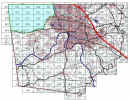
Index to Assessor's Property Maps
 |
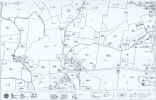
Example 1" = 400' Property Map
 |
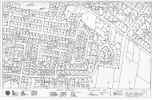
Example 1" = 100' Property Map
 |
Example Aerial Photography
 |
Geographic Information Systems
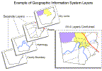
Until 1998, the maps created and maintained by the Assessor's office were hand-drafted on paper and plastic film. Whenever a change was made to the physical characteristics of a property, such as subdividing, combining or splitting of parcels, the maps were updated by re-inking the master maps. In 1998, the Assessor's office began conversion to a Geographic Information System or GIS. The GIS stores maps as computer databases. Different attributes are stored in separate layers in the system. One layer might store parcel boundaries and characteristics, another roads and streets, another zoning, and so on. Various types of analysis can be performed or visually depicted by overlaying or merging the different layers.
Layer Representation:
Additionally, the Montgomery County Assessor of Property's computer-assisted mass appraisal (CAMA) database, which contains all of the detailed property information about each parcel (ownership, sales history, improvements, etc.) is linked to the parcel layer of GIS. This provides a very powerful tool for accurately mapping all real properties in the jurisdiction and conducting a wide range of assessment analysis.
As part of a tri-party partnership between Montgomery County, the City of Clarksville, and Austin Peay State University, the local GIS system currently allows approximately 30 county and city departments to collect and share up-to-date geographic and statistical data to better provide essential services on a daily basis, and to plan more efficiently for the future. For additional information about the Clarksville / Montgomery County Geographic Information System Project and Center visit the APSU GIS Center.